Nuclear Missiles in Danvers

(In the Herald-Citizen, 9/4/2020)

Nike Hercules missiles - US Army - Nat Park Service
Nike Hercules missiles in firing position. US Army press photo/National Park Service.

Just north of the Putnamville Reservoir in Danvers was one of the frontlines of the Cold War. Pointing skyward in their launchers atop a fortified concrete bunker, white-and-gray nuclear-tipped missiles stood ready to defend the United States from Soviet attack.

Army bases with Nike missiles, such as the one in Danvers, were built surrounding major American cities, with 12 such bases around Boston. The three sites on the North Shore – at the Beverly side of Beverly Airport, Nahant, and Danvers – came online by 1955. In the era before intercontinental ballistic missiles, the biggest nuclear threat facing the United States was the possibility of Soviet bombers dropping atomic bombs on American cities, especially along the coast. Originally carrying only conventional warheads, the missiles in Danvers had a range of just 25 miles and were designed to be launched into the Massachusetts skies to destroy enemy planes if Soviet bombers were attacking Boston.

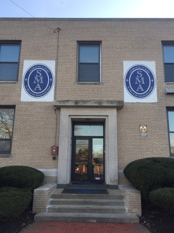
Each missile battery was split into two halves, a radar/control site and the launch site. In Danvers, the radar/control site was on a hill off North Street, which today is the Lt. John A. Fera United States Army Reserve Center. Fera, a Danvers resident, was killed in action in Vietnam in 1968. This site hosted several radar emplacements that would track the enemy planes and guide a missile towards them.

Today, many of the original buildings at the radar/command site remain, but are used for other purposes, and although the radar towers were removed, the large concrete pads that they were situated on remain visible. When originally built, this radar post was isolated, surrounded by fields and forest, though today the nearby neighborhood comes right up to the fence surrounding the site.

21468820
Photo of Radar/control station off North Street in 1959, with view of the reservoir to the north. From: http://coldwar-ma.com/
Army Reserve 2020
A similar view in 2020. Google Earth.

The second half of the base, the missile launch site, was across the Putnamville Reservoir, along the Danvers/Topsfield line off Route 1. This installation, which could be seen from the radar site across the water, was a long rectangular area split into thirds. The first part was a circle of identical ranch-style houses right off Route 1 built for the base’s officers. Beyond that is a gate and guard tower that led into the section of the base with the barracks and armory. The final section was the launch area at the farthest end of the base, in the woods north of the reservoir.

21468814
Photo of Nike launch site on north side of the reservoir in 1959. From: http://coldwar-ma.com/
Nike Launch Site 2010 Google Earth
A similar view in 2010. Reservoir at bottom left, and the road at top is Route 1. Bridle Spur Road is the development being constructed alongside the base, in the field that was previously kept cut short as a fire break.

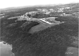
The launch area had small outbuildings in which missiles would be assembled. These buildings were surrounded by tall dirt berms that could contain a blast should there be any accidental rocket fuel explosions. Beyond these structures, on a slight rise a distance away, was a large rectangular concrete pad that had a long metal track that the missiles would slide across to reach their launchers, and three large steel doors that were flat with the ground. These doors covered elevators that brought the missiles up from the underground concrete bunker so that they could be launched.

01-Nike20Layout20Idealized_jpg
Image from a US Army brochure showing the launch area of a Nike site.
DentonNikeBase02a
This is an image of the launching area of a base in Texas that was identical to the launch area of the Danvers base. Note the missiles on the metal track and the three elevator doors at ground level that brought the missiles up form their underground storage bunker.

Although the Danvers base was known to exist, and its rough mission was known, in later years the original Nike Ajax missiles with conventional warheads were secretly switched out for nuclear-tipped Nike Hercules missiles – a fact unknown to most locals until years later. Although the payload changed to an atomic device roughly equivalent to what was dropped on Nagasaki and the range was increased to 75 miles, the mission did not change. The reason for the upgrade was that the original Nike Ajax missile could only take down one enemy aircraft per launch, and the radar could only guide one missile in flight at a time. What if the Soviets sent a whole formation of bombers? It was possible that not enough missiles could be launched in time to take down the planes one by one.

The US Government, therefore, decided that the best way to counter Soviet bombers was to add the nuclear element. If there was a fleet of enemy bombers approaching Boston, a Nike Hercules missile would be launched into the skies, the missile would collide with an enemy plane, and then the missile’s nuclear warhead would detonate in the skies over Massachusetts – or over the Atlantic along the Massachusetts coast. Sure, this weapon could bring down an entire formation of enemy planes, but even in the best-case scenario, there would be a Nagasaki-sized atomic blast detonated in the skies over Massachusetts, which seems…. less than ideal.

The Nike launch site in Danvers was decommissioned in 1974, once intercontinental ballistic missiles replaced bombers as the main Soviet threat to the US. The radar/control site on North Street remains an army post that has had varying uses in the years since. Nike missiles remained in use in Western Europe until the 1980s, when they were replaced with Patriot missiles that are still in service around the world.

Today, the former officers’ housing along Route 1 at the entrance of the launch site is now aptly named “Nike Village” and serves as community housing. Beyond that is a rusting chain-link gate with a decomposing wooden sentry post that guards the entrance to an abandoned and overgrown clump of deteriorated buildings. The underground missile storage bunker was sealed when the base was abandoned, no longer needed to defend the skies over Massachusetts.

2020 Base Gate
Gate to the launch site at Nike Village off Route 1 as it appears in 2020.
2020 Base Guardhouse
Guardhouse next to the main gate totally overgrown with brush.
2020 Base Road
Looking past the main gate at the road leading further into the launch site. What was once a wide road with buildings and open mowed areas on either side has been almost totally reclaimed by nature.

————————————————————————————–

ColdWar-MA. “B-05 Danvers.” Accessed August 26, 2020. http://coldwar-ma.com/B-05_Danvers.html.

Cummings, Nathan A. “Flying Treadmills, Cold War Whales: A Trip to Concord Field Station,” March 10, 2016. https://www.thecrimson.com/article/2016/3/10/concord-field-station/.

Nike Hercules Story, 1960. http://archive.org/details/nikeherc01.

Western Electric. U.S. Army Nike: In Defense of the Nation. Accessed August 26, 2020. http://www.usshelena.org/1nike.html.

Zollo, Richard P. From Muskets to Missiles: Danvers in Five Wars. Danvers, Mass.: R.P. Zollo, 2001.

Danvers Fallout Shelters

(March 13, 2020 in the Herald-Citizen)

During the Cold War, Americans across the country feared the outbreak of nuclear war – a conflict with the potential to end all life on earth. Once the Soviet Union detonated their first atomic bomb using stolen US intelligence in 1949, both sides had the capability of annihilating one another. Danvers, like towns across the country, took preparations in case the “hell bomb” fell.

During the 1950s, some citizens built makeshift fallout shelters in their cellars and constructed small concrete buildings in their backyards. The Danvers Chamber of Commerce worked with the VFW to construct an example home shelter on display near Danvers Square for interested Danversites to use as a model for their own homes. In 1961 and 1962, Massachusetts and local communities began planning and marking public fallout shelters in coordination with the local Civil Defense volunteers responsible for emergency preparedness.

Fallout Shelter Map-1
State CD fallout shelter map for Danvers. There are several errors including addresses and wrongly listing Our Lady of Assumption (which is in Lynnfield)
SMA 2
Saint Mary of the Annunciation School with fallout shelter sign, March 2020.

Danvers had public fallout shelters in all sections of town, which were located in the lowest levels of sturdy brick buildings and were to be used only if one could not take shelter in their own cellars. The fallout shelters in Danvers included Xavier Hall at St. John’s Prep on Spring St., St. Mary’s School on Otis St., Great Oak School on Pickering St., Danvers Savings Bank in the Square, the telephone exchange (Verizon building) on High St., Creese and Cook Tannery on Water St., Danvers State Hospital (with 11 shelters and a total capacity of 3,000 people), and the Sylvania building at 75 Sylvan St. These shelters were overseen by the local Civil Defense Committee, which stocked them with supplies such as snacks, flashlights, water, radios, and flashlights, but those taking refuge were expected to bring supplies with them.

Telephone Exchange 1
Verizon Telephone Exchange (63 High St.) with fallout shelter sign, March 2020.

Civil Defense had a chain of command, and at the state level it was headquartered in the governor’s nuclear bunker in Framingham, where the Massachusetts Emergency Management Agency is based today. In addition to the state director, there was a regional director, town director, and local volunteer neighborhood wardens. Unlike the military side of national defense, women had important roles in the Massachusetts Civil Defense, serving as local wardens and assistant regional directors.

Danvers’ Civil Defense Committee was established in 1950 and was based in the cellar of town hall before moving to the cellar of the old police station on Maple St. across from Hotwatt. On the tower atop the old Central Fire Station (where Atlantic Ambulance is today) next to the old police station was a radio antenna that, along with a second one at the DPW garage on Hobart St., could communicate with all sections of town. For public warning, air raid sirens were constructed at Plains Park and on Route 1 near the state hospital. These sirens were regularly tested, though there was one incident during the summer of 1964 when the air attack sirens went off accidentally and threw the town into a panic.

Air Raid Sirens
Danvers air raid sirens, 1959.

Civil Defense trained locals in first aid, showed preparedness films such as “You Can Beat the A-Bomb” to local civic groups, established an emergency electrical generator system for Hunt Hospital, organized blood drives, and established a volunteer  auxiliary police force for emergencies when Danvers did not have enough regular officers. Interestingly, during several years in the 1950s this special police force was called out on Halloween to manage the shenanigans of teenagers, which must have been quite out of hand. Civil Defense even had its own marked cars and trucks that were given to local communities from army surplus.

Civil Defense Trucks
Danvers Civil Defense vehicles at Hobart St. DPW Garage, 1957.

In addition to the nuclear attack preparedness associated with civil defense, the organization was also responsible for all types of emergencies: epidemics, floods, earthquakes, large fires, hurricanes, release of radiation from the Seabrook and Plymouth nuclear power plants, aircraft crashes, blackouts (such as the 1965 Northeast Blackout), and riots. If the town’s Civil Defense Director received the secret code word – in 1973 it was “MAYFLOWER” – from state officials he would mobilize all local resources to deal with whichever type of disaster was occurring, alerting the police and fire departments, the selectmen, the Civil Defense volunteers, the police auxiliary volunteers, and the Civil Air Patrol volunteers at Beverly Airport.

CD First Aid Kit (1)
This Civil Defense first aid kit from 1955 and Geiger counter were kept in the Public Health Dept. at Danvers Town Hall until March 2020. Pictured here after it was donated to the Danvers Archival Center, March 2020.

Geiger Counter (1)

Along with these public programs, the threat of nuclear annihilation also spurred private citizens to act. One private endeavor in Danvers that dwarfs all others was Galo Putnam Emerson Sr.’s “doomsday motel” project. Emerson, the then-owner of Putnam Pantry Candies on Rt. 1, planned to build a “bomb shelter motel” – an ordinary motel with an enormous fallout shelter in the cellar.

Noah's Ark-1
Boston Globe article on the planned fallout shelter motel, 1961.

The motel fallout shelter was meant to contain 6 months of supplies, including four giant underground tanks filled with fuel oil, kerosene, gasoline and water. Those saved by this shelter would be local Civil Defense officials, town leaders, medical professionals, a lawyer, estate planner – one might think that his job needed to be completed before the bomb fell – mechanic, farmer, fisherman, chemist, cook, teacher, and machine gunner, among other specialists. In addition to these professionals, the shelter was designed to include local citizens and whichever motel guests happened to be there, whose job was to repopulate Oniontown. To aid them in reestablishing humanity, the shelter included what the Boston Globe referred to as a “nuclear Noah’s Ark” – a cow, bull, rooster, chickens, seeds, farm equipment, and fishing gear.

Groundbreaking ceremonies for this last resort were held on November 14, 1961, and included guests such as the project’s engineer F. Parker Reidy, Danvers Town Manager Daniel J. McFadden, Chairman of the Board of Selectmen Baron Mayer, and Massachusetts Civil Defense Director John J. Maginnis. However, it does not appear that the project continued any further then this ceremony due to the costs involved.

To directly counter the atomic threat, Danvers and Beverly each had a missile base equipped with Nike nuclear-tipped missiles to defend against the “Red menace.” These bases, which will be described in a future article, made Danvers and Beverly frontline communities during this period of atomic fear.

—————————————————————————————————————————

Sources:

Danvers, Town of. 1950-1970 Annual Town Reports. Danvers, Mass.: Town of Danvers, 1956.

“‘Doomsday Motel’ Dream: The Danvers Candy Man Who Hoped To Build Underground Bomb Shelter.” Boston, Mass.: WBUR, March 2, 2017. https://www.wbur.org/news/2017/03/02/danvers-doomsday-motel.

Massachusetts Civil Defense Agency. Community Shelter Plans: Essex County, Middlesex County, Suffolk County, 1979. http://archive.org/details/communityshelter00mass_1.

Massachusetts Civil Defense Agency, and United States Office of Emergency Preparedness. Massachusetts State Disaster Plan, 1973. http://archive.org/details/massachusettssta00mass_2.

Sullivan, Jerome. “General Putnam Descendant Builds Nuclear Noah’s Ark.” Boston Globe; Boston, Mass. November 15, 1961.